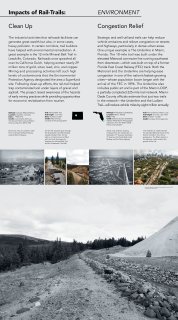
Clean Up
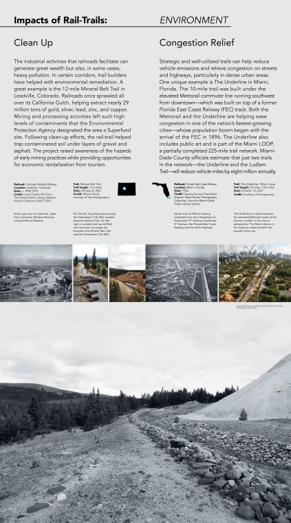
The industrial activities that railroads facilitate can generate great wealth but also, in some cases, heavy pollution. In certain corridors, trail builders have helped with environmental remediation. A great example is the 12-mile Mineral Belt Trail in Leadville, Colorado. Railroads once sprawled all over its California Gulch, helping extract nearly 29 million tons of gold, silver, lead, zinc, and copper. Mining and processing activities left such high levels of contaminants that the Environmental Protection Agency designated the area a Superfund site. Following clean-up efforts, the rail-trail helped trap contaminated soil under layers of gravel and asphalt. The project raised awareness of the hazards of early mining practices while providing opportunities for economic revitalization from tourism.
Railroad: Colorado Midland Railway
Location: Leadville, Colorado
Date: c. 1900-1910
Credit: Louis Charles McClure, The Denver Public Library, Western History Collection, [MCC-935]
Bird’s eye view of Leadville, taken from Colorado Midland Railway towards Mount Massive.
-
-
Trail: Mineral Belt Trail
Trail length: 11.6 miles
Date: October 8, 2021
Credit: Wayne Kemp, courtesy of the photographer
On the left, bicyclists pass through the Greenback Crib Wall headed towards Graham Park. On the right, a containment pond filled with acid rock drainage sits between the Mineral Belt Trail and the Greenback Crib Wall.
---
---
Congestion Relief
Strategic and well-utilized trails can help reduce vehicle emissions and relieve congestion on streets and highways, particularly in dense urban areas. One unique example is The Underline in Miami, Florida. The 10-mile trail was built under the elevated Metrorail commuter line running southwest from downtown—which was built on top of a former Florida East Coast Railway (FEC) track. Both the Metrorail and the Underline are helping ease congestion in one of the nation’s fastest-growing cities—whose population boom began with the arrival of the FEC in 1896. The Underline also includes public art and is part of the Miami LOOP, a partially completed 225-mile trail network. Miami-Dade County officials estimate that just two trails in the network—the Underline and the Ludlam Trail—will reduce vehicle miles by eight million annually.
Railroad: Florida East Coast Railway
Location: Miami, Florida
Date: 1936
Credit: Clarence Duncan Chamberlin,
Gleason Waite Romer Photographs Collection, from the Miami-Dade Public Library System
Aerial view of Miami looking northeast from the intersection of Southwest 17th Avenue, Southwest 3rd Avenue, the Florida East Coast Railway, and the Dixie Highway.
-
-
Trail: The Underline / Miami Loop
Trail length: 10 miles / 225 miles
Date: October 13, 2021
Credit: Courtesy of Dronegenuity
The Underline is visible beneath the elevated Metrorail tracks at the bottom middle in this drone perspective. The Miami skyline in the distance makes evident the growth of the city.
-
-
Caption: Green Back Mine Area, Leadville, Colorado (detail), October 8, 2021. Photograph by Wayne Kemp