Speed, John. The Kingdome of China. London: Are to be sold in Popshead Alley by G. Humble, 1626.
約翰.史畢《中國王國》 ,倫敦:Are to be sold in Popshead Alley by G. Humble,1626。
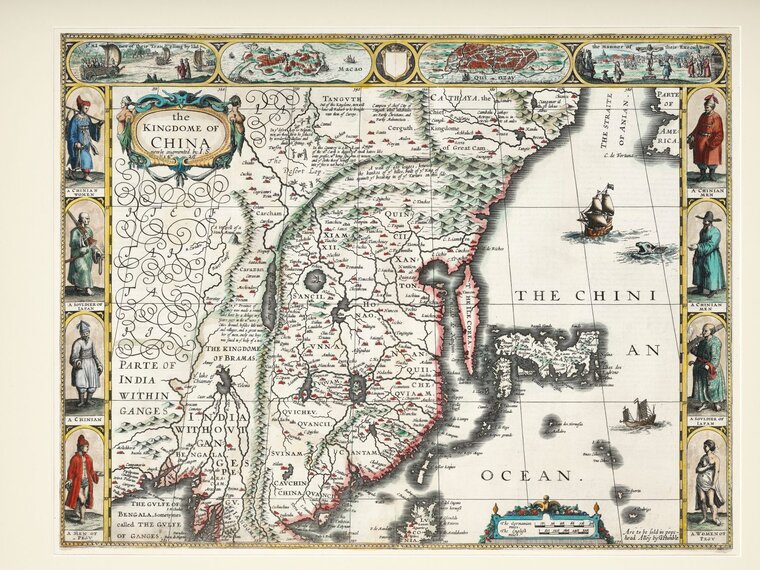
The first map of China printed in England. Centred on Ming China, it includes Japan as well as the Ile Corea (the "island" of Korea). The Great Wall is depicted on the map, along with several annotations. The decorative panel at the top includes city views of Macao and Qyinzay (Hangzhou, an important missionary centre during the late Ming and early Qing). There are also images of the Chinese “sailing chariots” and crucifixion, a reference to the execution of Christians by the Tokugawa in Japan. The inhabitants of the region are shown at sides, including the costumed figures of Chinese, Japanese soldiers and Pegu (Burmese) men and women.
這是第一幅在英格蘭印刷的中國地圖。此地圖以明朝中國為中心,並加入日本及韓國「島」的位置;它亦標示長城的位置及配以描述。地圖上方畫有澳門與行在(即杭州,明末清初的一個重要傳教中心)的城市景觀,以及中國的「帆船戰車」和十字架圖像,以呼應這一時期日本德川幕府處決基督徒的情況。地圖兩側則繪有中國、日本、佩古(即緬甸)的男女的畫像。