John Angus is an artist, designer, print-maker, researcher, and curator, based in Lancaster, UK. He originally trained in biology at Liverpool and Birmingham universities. From 1975-2005 he designed and screen-printed posters for arts organisations throughout UK. His posters have been widely exhibited and are in public collections, including the Victoria & Albert Museum, and have been reproduced in several books.
He was a founder of arts and health company, Pioneer Projects, creating art works for primary care and hospitals (1988-2005), and was a research associate at Durham University, publishing reports on art in community health.
He produced a series of artworks about plankton, which were exhibited as light projections on Morecambe sea front promenade, and as prints in four Lancashire Museums, and Oxford University Museum of Natural History (2001-2008).
In 1991 he was one of group of artists which formed Storey Gallery in Lancaster, later becoming Director, curating a contemporary art programme until 2013. Since then he has continued this company, now known as StoreyG2, commissioning art projects about landownership.
He started print-making again in 2013 at ArtLab Contemporary Print Studio, at the University of Central Lancashire, in Preston. His recent prints have been exhibited widely in the UK, and also in China.
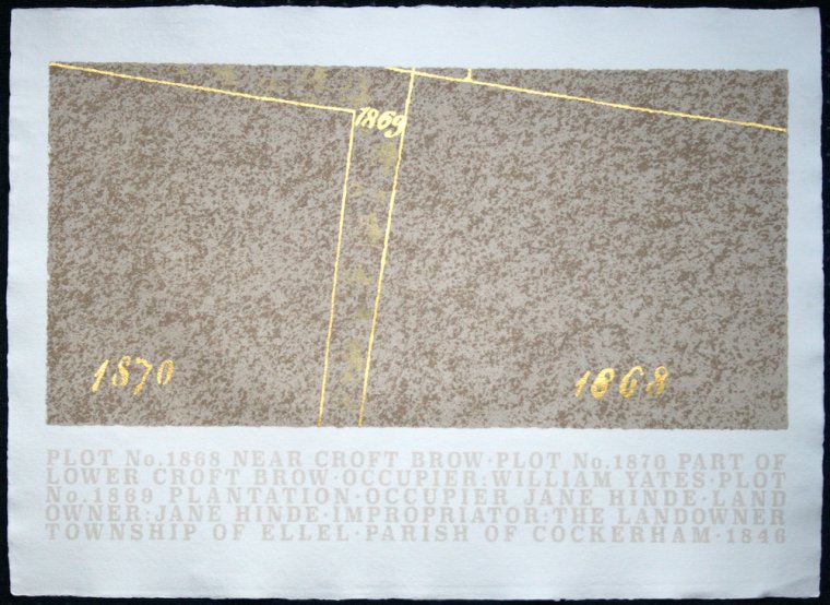
''Over the past few years I have been researching the history of landownership of an area near where I live. The selected area is an east-west slice of north Lancashire from the remains of Cockersand Abbey on the coast, across upper Wyre, to the Trough of Bowland. This geographic slice includes seacoast with salt marsh tidal flats, farmland which has been reclaimed by sea defences, higher farmland, and moorland, including grouse moors. There are north-south transport routes through it including the Lancaster to Preston canal, the A6 main road, the west coast mainline railway, and the M6 motorway. It lies between the Ordnance Survey nothing lines 52 to 55, and easting 40 to 63. This is about 14,000 acres, roughly 12 miles from west to east, 1¾ miles north-south.
More details at https://storeys2.org.uk/landed-cadastral-maps/
The images are based on small sections of Tithe Maps for the research study area which were produced in the mid nineteenth century and which show the names of the owner and occupier of every plot of land. They were screen printed with mud from the estuary of the river Lune, close to where I live, and the details screen printed and hand-painted with gold acrylic.''